


Lopez 2 Voting District, San Juan County, Washington
About
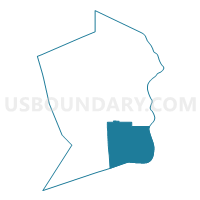
Outline

Summary
| Unique Area Identifier | 688303 |
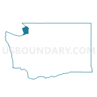
| Name | Lopez 2 Voting District |
| County | San Juan County |
| State | Washington |
| Area (square miles) | 76.34 |
| Land Area (square miles) | 18.62 |
| Water Area (square miles) | 57.73 |
| % of Land Area | 24.38 |
| % of Water Area | 75.62 |
| Latitude of the Internal Point | 48.42267930 |
| Longtitude of the Internal Point | -122.84991960 |
Maps

Graphs
Select a template below for downloading or customizing gragh for Lopez 2 Voting District, San Juan County, Washington


Neighbors
Neighoring Voting District (by Name) Neighboring Voting District on the Map
- Blakely/Decatur Voting District, San Juan County, WA
- Burrows Bay, Skagit County, WA
- Lopez 1 Voting District, San Juan County, WA
- San Juan 1 Voting District, San Juan County, WA
- Water: Strait of Juan de Fuca, Island County, WA
- Water: Strait of Juan de Fuca, Jefferson County, WA
Top 10 Neighboring County Subdivision (by Population) Neighboring County Subdivision on the Map
- North Whidbey Island CCD, Island County, WA (36,757)
- Anacortes CCD, Skagit County, WA (20,332)
- Discovery Bay-Port Townsend CCD, Jefferson County, WA (15,833)
- San Juan Island CCD, San Juan County, WA (7,662)
- Lopez CCD, San Juan County, WA (2,753)
Top 10 Neighboring Unified School District (by Population) Neighboring Unified School District on the Map
- Oak Harbor School District, WA (37,813)
- Anacortes School District, WA (20,332)
- Port Townsend School District, WA (14,278)
- San Juan Island School District, WA (7,662)
- Lopez School District, WA (2,480)
Top 10 Neighboring State Legislative District Lower Chamber (by Population) Neighboring State Legislative District Lower Chamber on the Map
- State House District 40, WA (138,925)
- State House District 10, WA (134,117)
- State House District 24, WA (132,679)
Top 10 Neighboring State Legislative District Upper Chamber (by Population) Neighboring State Legislative District Upper Chamber on the Map
- State Senate District 40, WA (138,925)
- State Senate District 10, WA (134,117)
- State Senate District 24, WA (132,679)
Top 10 Neighboring 111th Congressional District (by Population) Neighboring 111th Congressional District on the Map
Top 10 Neighboring Census Tract (by Population) Neighboring Census Tract on the Map
- Census Tract 9505, Jefferson County, WA (6,514)
- Census Tract 9603, San Juan County, WA (4,761)
- Census Tract 9605, San Juan County, WA (2,753)
- Census Tract 9901, San Juan County, WA (0)
- Census Tract 9922.01, Island County, WA (0)
- Census Tract 9901, Skagit County, WA (0)